Slider

viernes, 17 de junio de 2016

Margarita Island

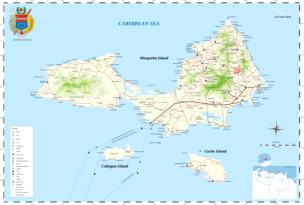
Margarita Island is the largest island in the Venezuelan state of Nueva Esparta, situated off the northeastern coast of the country, in the Caribbean Sea. The capital city of Nueva Esparta, La Asunción, is located on the island. Primary industries are tourism, fishing and construction.

       Located in the Caribbean Sea between latitudes 10°52'N and 11°11'N and longitudes 63°48'W and 64°23'W, the island, along with the islands of Coche and Cubagua, comprises the state of Nueva Esparta. The island is split into two peninsula joined by an 18 kilometres long ithnus and covers an area of 1,020 km². It is 78 kilometres long and measures roughly 20 kilometres at its widest. The climate is sunny and dry with average temperatures ranging from 24 to 37 °C.
Most of the island's 420,000 residents live in the more developed eastern part of the island, which includes the large cities of Porlamar and Pampatar along with the state capital of La Asunción. The island can be reached by direct flights from Caracas or ferries from Puerto La Cruz, Cumaná, and La Guaira. There are no international flights to the island at present.


The Macanao Peninsula to the west has a central mountain range in the east-west direction. The highest altitude is 760 metres at Pico de Macanao. Several smaller ranges derive from this axis following a north-south orientation with deep valleys between them. The most notable of these valleys is San Francisco in the north-central part of the peninsula. The Paraguachoa peninsula to the East is formed by a mountain range in the north-south direction from Porlamar to Cabo Negro. The highest peaks are San Juan or Cerro Grande at 920 metres and El Copey 890 metres. The peninsulas are connected by the La Restinga isthmus, on which the La Restinga Lagoon is located. There are also two breast  shaped hills known as Tetas de Maria Guevara on the isthmus.

Angel Falls (Salto Ángel)

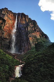
Angel Falls or salto Ángel in spanish is a waterfall in Venezuela. It is the world's highest uninterrupted waterfall, with a height of 979 metres and a plunge of 807 metres. The waterfall drops over the edge of the Auyantepui mountain in the Canaima National Park (Spanish: Parque Nacional Canaima), a UNESCO World Heritage site in the Gran Sabana region of Bolívar State. The height figure 979 metres mostly consists of the main plunge but also includes about 400 metres of sloped cascade and rapids below the drop and a 30-metre high plunge downstream of the talus rapids. The falls are along a fork of the Rio Kerepacupai Meru which flows into the Churun River, a tributary of the Carrao River, itself a tributary of the Orinoco River.
Angel Falls is one of Venezuela's top tourist attractions, though a trip to the falls is a complicated affair. The falls are located in an isolated jungle. A flight from Puerto Ordaz orCiudad Bolívar is required to reach Canaima camp, the starting point for river trips to the base of the falls. River trips generally take place from June to December, when the rivers are deep enough for use by the Pemon guides. During the dry season (December to March) there is less water seen than in the other months.
SaltoAngel4.jpg

jueves, 26 de mayo de 2016

Meet Venezuela

        Venezuela is located in the north of South America. It has a total area of 916,445 km2. making it the 33rd largest country in the world.Venezuela is one of the few countries that has all the types of climates , savannah , snow, beach , plains, etc.
     All these climates make Venezuela an exelent country to travel because you can find the climate that you want in the same country, so you can make a trip to Venezuela and stay some days in different places to see diferent climates.


        A trip to venezuela can be very cheep because of the price of the dollar now a days so with few dollars you can stay many days in Venezuela.